Multi-sensor fusion-based mapping and path planning system for autonomous navigation of a unicycle-type mobile robot
DOI:
https://doi.org/10.37636/recit.v9n3e465Keywords:
Path planning, WMR, A*, Ray casting, Occupancy mapsAbstract
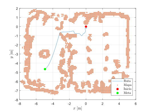
This paper presents a mapping and path planning system for a unicycle-type wheeled mobile robot (WMR), implemented on the AmigoBot platform, aimed at enabling autonomous navigation from a starting position to a defined destination within a structured environment. The system comprises three main components: occupancy map generation and visualization, trajectory planning, and motion control with obstacle avoidance. Implementation was carried out using the Robot Operating System (ROS) and the Advanced Robotics Interface for Applications (ARIA) architecture. The environmental representation is constructed by fusing data from an ultrasonic sensor array and a Kinect depth camera. Data fusion is achieved through the intersection of binary maps, complemented by neighborhood-based spatial filtering to smooth out local inconsistencies in the occupancy grid. Path planning relies on the A* algorithm, followed by a geometric simplification stage using ray casting to reduce the number of nodes in the trajectory. Path following is implemented via a proportional controller based on pose error (position and orientation), incorporating a reactive obstacle avoidance scheme based on repulsive potential fields. Experimental results demonstrate that the system achieves a 92% reduction in the number of nodes from the original path and a 62.5% reduction in inflection points, thanks to the geometric simplification process. In real-time autonomous navigation tests, the robot successfully completed the trajectory in 1 minute and 32 seconds, maintaining the tracking error relative to control points below 0.25 m during transitions. In the presence of additional unmapped obstacles, the reactive module ensured a 100% success rate in collision avoidance, recording a minimum safety distance of 3.6 cm in the environment's most spatially constrained areas. These results demonstrate that the proposed software architecture is capable of generating consistent occupancy maps, planning efficient trajectories with low geometric complexity, and executing safe autonomous navigation within the experimental environment.
Downloads
References
[1] A. Giannaros, A. Karras, L. Theodorakopoulos, C. Karras, P. Kranias, N. Schizas, et al., “Autonomous vehicles: Sophisticated attacks, safety issues, challenges, open topics, blockchain, and future directions,” Journal of Cybersecurity and Privacy, vol. 3, no. 3, pp. 493–543, 2023, doi: 10.3390/jcp3030025. DOI: https://doi.org/10.3390/jcp3030025
[2] A. Taheri and Z. C. Xia, “SLAM; definition and evolution,” Engineering Applications of Artificial Intelligence, vol. 97, 2021, Art. no. 104032, doi: 10.1016/j.engappai.2020.104032. DOI: https://doi.org/10.1016/j.engappai.2020.104032
[3] Z. Ren, L. Wang, and L. Bi, “Robust GICP-based 3D LiDAR SLAM for underground mining environment,” Sensors, vol. 19, no. 13, 2019, Art. no. 2915, doi: 10.3390/s19132915. DOI: https://doi.org/10.3390/s19132915
[4] M. Hao, J. Ren, X. Ji, Y. Bi, S. Zhao, and M. Wu, “Research on multimodal data enhanced SLAM algorithm for global mapping of underground coal mines,” Scientific Reports, vol. 15, no. 1, 2025, Art. no. 37124, doi: 10.1038/s41598-025-37124-0. DOI: https://doi.org/10.1038/s41598-025-21053-y
[5] Y. Huang, J. McConnell, X. Lin, and B. Englot, “DRACo-SLAM2: Distributed Robust Acoustic Communication-efficient SLAM for Imaging Sonar Equipped Underwater Robot Teams with Object Graph Matching,” in 2025 IEEE/RSJ International Conference on Intelligent Robots and Systems (IROS), IEEE, 2025, pp. 3587–3594, doi: 10.1109/IROS62453.2025.10970000. DOI: https://doi.org/10.1109/IROS60139.2025.11246631
[6] M. Heshmat, L. Saad Saoud, M. Abujabal, A. Sultan, M. Elmezain, L. Seneviratne, and I. Hussain, “Underwater SLAM meets deep learning: challenges, multi-sensor integration, and future directions,” Sensors, vol. 25, no. 11, 2025, Art. no. 3258, doi: 10.3390/s25113258. DOI: https://doi.org/10.3390/s25113258
[7] J. Lim and K. H. Chon, “Minimax Rao-blackwellized particle filtering in 2D LiDAR SLAM,” International Journal of Control, Automation and Systems, vol. 22, no. 6, 2024, pp. 1947–1957, doi: 10.1007/s12555-023-0268-z. DOI: https://doi.org/10.1007/s12555-023-0268-z
[8] T. P. Kucner, M. Magnusson, S. Mghames, L. Palmieri, F. Verdoja, C. S. Swaminathan, et al., “Survey of maps of dynamics for mobile robots,” The International Journal of Robotics Research, vol. 42, no. 11, pp. 977–1006, 2023, doi: 10.1177/02783649231169812. DOI: https://doi.org/10.1177/02783649231190428
[9] I. Ullah, D. Adhikari, H. Khan, M. S. Anwar, S. Ahmad, and X. Bai, “Mobile robot localization: Current challenges and future prospective,” Computer Science Review, vol. 53, 2024, Art. no. 100651, doi: 10.1016/j.cosrev.2024.100651. DOI: https://doi.org/10.1016/j.cosrev.2024.100651
[10] L. Yang, P. Li, S. Qian, H. Quan, J. Miao, M. Liu, et al., “Path planning technique for mobile robots: A review,” Machines, vol. 11, no. 10, 2023, Art. no. 980, doi: 10.3390/machines11100980. DOI: https://doi.org/10.3390/machines11100980
[11] Z. Zhou, X. Feng, S. Di, and X. Zhou, “A LiDAR mapping system for robot navigation in dynamic environments,” IEEE Transactions on Intelligent Vehicles, 2023, doi: 10.1109/TIV.2023.3298456. DOI: https://doi.org/10.1109/TIV.2023.3328013
[12] L. Sun, Y. Zhang, and H. Yu, “Multi-sensor perception and spatial mapping for mobile robots in dynamic environments: A survey,” Robotics and Autonomous Systems, vol. 172, Art. no. 104590, 2024, doi: 10.1016/j.robot.2023.104590. DOI: https://doi.org/10.1016/j.robot.2023.104590
[13] J. Jung, Y. Lee, J. Park, and T. K. Yeu, “Multi-modal sonar mapping of offshore cable lines with an autonomous surface vehicle,” Journal of Marine Science and Engineering, vol. 10, no. 3, p. 361, 2022, doi: 10.3390/jmse10030361. DOI: https://doi.org/10.3390/jmse10030361
[14] H. Huang, L. Li, F. Cheng, and S. K. Yeung, “Photo-SLAM: Real-time simultaneous localization and photorealistic mapping for monocular stereo and RGB-D cameras,” in Proceedings of the IEEE/CVF Conference on Computer Vision and Pattern Recognition (CVPR), pp. 21584–21593, 2024, doi: 10.1109/CVPR52733.2024.02039. DOI: https://doi.org/10.1109/CVPR52733.2024.02039
[15] T. Grebner, A. Grathwohl, P. Schoeder, V. Janoudi, and C. Waldschmidt, “Probabilistic SAR processing for high-resolution mapping using millimeter-wave radar sensors,” IEEE Transactions on Aerospace and Electronic Systems, vol. 59, no. 5, pp. 4800–4814, 2023, doi: 10.1109/TAES.2023.10164269. DOI: https://doi.org/10.1109/TAES.2023.3289784
[16] S. Y. Alaba, “GPS-IMU Sensor Fusion for Reliable Autonomous Vehicle Position Estimation,” arXiv preprint arXiv:2405.08119, 2024, doi: 10.48550/arXiv.2405.08119.
[17] M. Münzinger, N. Prechtel, and M. Behnisch, “Mapping the urban forest in detail: From LiDAR point clouds to 3D tree models,” Urban Forestry & Urban Greening, vol. 74, 2022, Art. no. 127637, doi: 10.1016/j.ufug.2022.127637. DOI: https://doi.org/10.1016/j.ufug.2022.127637
[18] X. Liu, A. Prabhu, F. Cladera, I. D. Miller, L. Zhou, C. J. Taylor, and V. Kumar, “Active metric-semantic mapping by multiple aerial robots,” in 2023 IEEE International Conference on Robotics and Automation (ICRA), pp. 3282–3288, 2023, doi: 10.1109/ICRA48891.2023.10161564. DOI: https://doi.org/10.1109/ICRA48891.2023.10161564
[19] S. Zhao, P. Bhattacharya, and M. Han, “A review of visual-LiDAR fusion based simultaneous localization and mapping (SLAM) and metric-semantic mapping,” Robotics and Autonomous Systems, vol. 174, Art. no. 104642, 2024, doi: 10.1016/j.robot.2024.104642. DOI: https://doi.org/10.1016/j.robot.2024.104642
[20] K. Guo, W. Liu, and J. Pan, “End-to-End Trajectory Distribution Prediction Based on Occupancy Grid Maps,” in Proceedings of the IEEE/CVF Conference on Computer Vision and Pattern Recognition (CVPR), pp. 2242–2251, 2022, doi: 10.1109/CVPR52688.2022.00228. DOI: https://doi.org/10.1109/CVPR52688.2022.00228
[21] S. Sunil, S. Mozaffari, R. Singh, B. Shahrrava, and S. Alirezaee, “Feature-Based Occupancy Map-Merging for Collaborative SLAM,” Sensors, vol. 23, no. 6, 2023, Art. no. 3114, doi: 10.3390/s23063114. DOI: https://doi.org/10.3390/s23063114
[22] Z. An, X. Rui, and C. Gao, “Improved A* Navigation Path-Planning Algorithm Based on Hexagonal Grid,” ISPRS International Journal of Geo-Information, vol. 13, no. 5, 2024, Art. no. 166, doi: 10.3390/ijgi13050166. DOI: https://doi.org/10.3390/ijgi13050166
[23] M. E. Miyombo, Y. K. Liu, C. M. Mulenga, A. Siamulonga, M. C. Kabanda, P. Shaba, et al., “Optimal path planning in a real-world radioactive environment: A comparative study of A-star and Dijkstra algorithms,” Nuclear Engineering and Design, vol. 420, 2024, Art. no. 113039, doi: 10.1016/j.nucengdes.2024.113039. DOI: https://doi.org/10.1016/j.nucengdes.2024.113039
[24] H. Wang, S. Lou, J. Jing, Y. Wang, W. Liu, and T. Liu, “The EBS-A* algorithm: An improved A* algorithm for path planning,” PLOS ONE, vol. 17, no. 2, 2022, Art. no. e0263841, doi: 10.1371/journal.pone.0263841. DOI: https://doi.org/10.1371/journal.pone.0263841
[25] X. Li, Y. Lu, X. Zhao, X. Deng, and Z. Xie, “Path planning for intelligent vehicles based on improved D* Lite,” Journal of Supercomputing, vol. 80, no. 1, 2024, Art. no. 1294, doi: 10.1007/s11227-023-05528-1. DOI: https://doi.org/10.1007/s11227-023-05528-1
[26] H. Tu, Y. Deng, Q. Li, M. Song, and X. Zheng, “Improved RRT global path planning algorithm based on Bridge Test,” Robotics and Autonomous Systems, vol. 171, 2024, Art. no. 104570, doi: 10.1016/j.robot.2024.104570. DOI: https://doi.org/10.1016/j.robot.2023.104570
[27] “ROSARIA,” ROS Wiki. [Online]. Available: https://wiki.ros.org/ROSARIA
[28] “libfreenect,” ROS Wiki. [Online]. Available: https://wiki.ros.org/libfreenect
[29] “laserscan_kinect,” ROS Wiki. [Online]. Available: https://wiki.ros.org/laserscan_kinect
[30] Y. Gong, “OSBF: One-sided box filter for edge-preserving image processing,” IEEE Access, 2025, doi: 10.1109/ACCESS.2025.10942596. DOI: https://doi.org/10.1109/ACCESS.2025.3555434
[31] P. E. Hart, N. J. Nilsson, and B. Raphael, “A formal basis for the heuristic determination of minimum cost paths,” IEEE Transactions on Systems Science and Cybernetics, vol. 4, no. 2, pp. 100–107, 1968, doi: 10.1109/TSSC.1968.300136. DOI: https://doi.org/10.1109/TSSC.1968.300136
[32] H. K. Balakrishnan, A. Suryan, A. P. Alex, S. S. Raj, and G. Zhang, “Heuristic evaluation in A-star algorithm for enhanced urban UAV path optimization,” SSRN Electronic Journal, 2025, doi: 10.2139/ssrn.5079937. DOI: https://doi.org/10.2139/ssrn.5079937
[33] U. Karki and P. J. Parikh, “Visibility-based layout of a hospital unit—An optimization approach,” Health Care Management Science, vol. 27, no. 2, 2024, doi: 10.1007/s10729-023-09662-1. DOI: https://doi.org/10.1007/s10729-024-09670-x
[34] Y. Zhang, Y. Hu, J. Lu, and Z. Shi, “Research on path planning of mobile robot based on improved Theta* algorithm,” Algorithms, vol. 15, no. 12, Art. no. 477, 2022, doi: 10.3390/a15120477. DOI: https://doi.org/10.3390/a15120477
[35] J. Zhang, P. Tsiotras, and Y. Yan, “Visibility-aware trajectory optimization for mobile robots in cluttered environments,” in 2021 IEEE International Conference on Robotics and Automation (ICRA), pp. 9823–9829, 2021, doi: 10.1109/ICRA48506.2021.9561021. DOI: https://doi.org/10.1109/ICRA48506.2021.9561021
[36] D. A. Daohong Liu, “Research of the Path Finding Algorithm A* in Video Games,” Highlights in Science, Engineering and Technology, vol. 39, pp. 763–768, 2023, doi: 10.54097/hset.v39i.6642. DOI: https://doi.org/10.54097/hset.v39i.6642
Downloads
Published
Issue
Section
Categories
License
Copyright (c) 2026 Gilberto Ramos, Luis Arturo García Delgado, Ricardo Ramón Pérez Alcocer

This work is licensed under a Creative Commons Attribution 4.0 International License.
The authors who publish in this journal accept the following conditions:
The authors retain the copyright and assign to the journal the right of the first publication, with the work registered with the Creative Commons Attribution license 4.0, which allows third parties to use what is published as long as they mention the authorship of the work and the first publication in this magazine.
Authors may make other independent and additional contractual agreements for the non-exclusive distribution of the version of the article published in this journal (eg, include it in an institutional repository or publish it in a book) as long as they clearly indicate that the work it was first published in this magazine.
Authors are allowed and encouraged to share their work online (for example: in institutional repositories or personal web pages) before and during the manuscript submission process, as it can lead to productive exchanges, greater and more quick citation of published work (see The Effect of Open Access).
How to Cite